


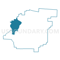
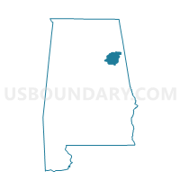
Ohatchee First Baptist Voting District, Calhoun County, Alabama
About
Outline

Summary
| Unique Area Identifier | 521309 |
| Name | Ohatchee First Baptist Voting District |
| County | Calhoun County |
| State | Alabama |
| Area (square miles) | 42.61 |
| Land Area (square miles) | 40.70 |
| Water Area (square miles) | 1.91 |
| % of Land Area | 95.52 |
| % of Water Area | 4.48 |
| Latitude of the Internal Point | 33.80812930 |
| Longtitude of the Internal Point | -86.00343610 |
Maps

Graphs
Select a template below for downloading or customizing gragh for Ohatchee First Baptist Voting District, Calhoun County, Alabama


Neighbors
Neighoring Voting District (by Name) Neighboring Voting District on the Map
- Boiling Springs Baptist Voting District, Calhoun County, AL
- Eulaton/Bynum/West Park Heights Bapt. Voting District, Calhoun County, AL
- Greensport Comm Center Voting District, St. Clair County, AL
- Mt. View Baptist Church Voting District, Calhoun County, AL
- Oak Grove Baptist Voting District, Calhoun County, AL
- Poplar Springs/Gum Springs Church/Oldham Chapel Voting District, St. Clair County, AL
- Ragland Town Hall Voting District, St. Clair County, AL
- Southside H S Old Lunchroom, Etowah County, AL
Top 10 Neighboring County Subdivision (by Population) Neighboring County Subdivision on the Map
- Gadsden CCD, Etowah County, AL (72,028)
- Anniston CCD, Calhoun County, AL (68,662)
- Alexandria-Webster Chapel CCD, Calhoun County, AL (11,730)
- Ashville CCD, St. Clair County, AL (8,449)
- Ragland CCD, St. Clair County, AL (5,509)
- Ohatchee CCD, Calhoun County, AL (4,615)
Top 10 Neighboring Place (by Population) Neighboring Place on the Map
Top 10 Neighboring Unified School District (by Population) Neighboring Unified School District on the Map
- Etowah County School District, AL (60,417)
- Calhoun County School District, AL (57,392)
- St. Clair County School District, AL (53,540)
Top 10 Neighboring State Legislative District Lower Chamber (by Population) Neighboring State Legislative District Lower Chamber on the Map
- State House District 40, AL (49,653)
- State House District 36, AL (46,065)
- State House District 30, AL (44,979)
Top 10 Neighboring State Legislative District Upper Chamber (by Population) Neighboring State Legislative District Upper Chamber on the Map
Top 10 Neighboring 111th Congressional District (by Population) Neighboring 111th Congressional District on the Map
- Congressional District 6, AL (754,482)
- Congressional District 3, AL (681,298)
- Congressional District 4, AL (660,162)
Top 10 Neighboring Census Tract (by Population) Neighboring Census Tract on the Map
- Census Tract 105.01, Etowah County, AL (8,191)
- Census Tract 25.01, Calhoun County, AL (7,069)
- Census Tract 403, St. Clair County, AL (5,509)
- Census Tract 105.02, Etowah County, AL (4,988)
- Census Tract 404.01, St. Clair County, AL (4,731)
- Census Tract 25.02, Calhoun County, AL (4,661)
- Census Tract 26, Calhoun County, AL (4,615)
- Census Tract 9819.02, Calhoun County, AL (5)